Cyclone Montha Weakens After Landfall, Heavy Rain Alerts Span 18 Indian States Through November 2

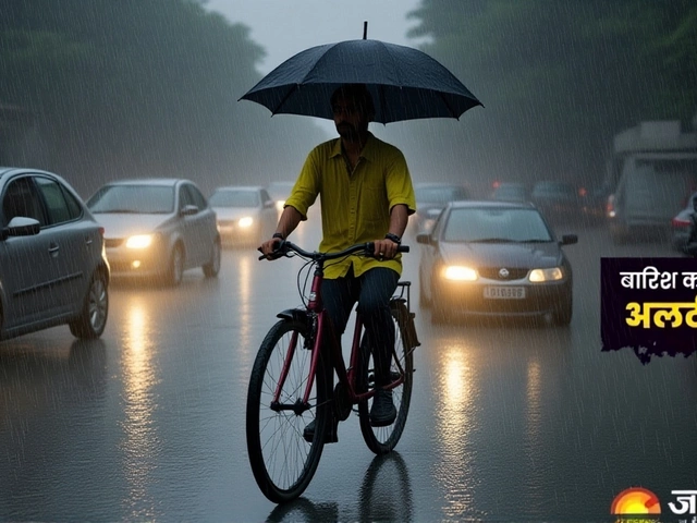
When India Meteorological Department issued its final bulletin on October 30, 2025, the once-feared Cyclone Montha had lost its teeth—but not its threat. The storm, which slammed into the Andhra Pradesh coast between Machilipatnam and Kalingapatnam late on October 28, had weakened to a deep depression by midday Thursday, leaving behind two dead, flooded streets, and fields drowned in saltwater. What followed wasn’t calm. It was a slow-motion deluge stretching across 18 states, fueled by the storm’s lingering moisture and a fresh depression forming over the Arabian Sea. The real danger wasn’t the wind anymore. It was the rain. And it wasn’t stopping anytime soon.
From Storm to Soak: How Montha Transformed
Cyclone Montha struck with a punch: 90–100 km/h sustained winds, gusts up to 110 km/h, and a storm surge that swallowed low-lying coastal villages near Kakinada. By 8:30 a.m. on October 29, isolated spots in Coastal Andhra Pradesh had already recorded over 20 cm of rain in 24 hours. The India Meteorological Department had raised a red alert for the region, warning of life-threatening conditions. But by the time the sun rose on October 30, the system had slumped into a well-marked low-pressure area over south Chhattisgarh, its center now 200 kilometers inland.That’s when the real chaos began. Without the cyclone’s organized rotation, the rain didn’t stop—it spread. The IMD’s models showed moisture from the Bay of Bengal colliding with a separate low-pressure system over the Arabian Sea. The result? A rain machine spanning from Gujarat to West Bengal. What was once a localized disaster became a national weather event.
18 States, One Warning: The Rain Domino Effect
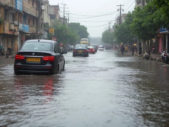
The India Meteorological Department issued alerts across an unprecedented stretch of the country. In the west, Saurashtra and Kutch braced for isolated very heavy rainfall through November 1, with roads already turning into rivers in Junagadh and Bhavnagar. In the south, Kerala and Coastal Karnataka saw thunderstorms with gusts up to 50 km/h, knocking out power in multiple towns. Meanwhile, in the east, the rain had migrated to West Bengal’s northern hills.By October 31, the IMD warned that Darjeeling and Kalimpong could see 7–11 cm of rain—enough to trigger landslides on already saturated slopes. In Malda and Dinajpur, residents were told to keep sandbags ready. The rainfall wasn’t just heavy; it was persistent. “This isn’t a single downpour,” said Dr. Arjun Mehta, a senior climatologist at the India Meteorological Department. “It’s a series of pulses, each one refilling what the last one washed away.”
Even inland, the impact was visible. In Madhya Pradesh’s Nimar region, farmers watched as their soybean crops—just weeks from harvest—turned to mush. In Maharashtra’s Marathwada, reservoirs filled faster than expected, forcing the state to open dam gates earlier than planned. The India Meteorological Department didn’t just predict rain. It predicted cascading failure: flooded roads, disrupted rail lines, delayed medical evacuations, and power outages from waterlogged transformers.
Andhra Pradesh: The Eye That Didn’t Close
While the cyclone’s center moved north, Andhra Pradesh never fully escaped its shadow. An orange alert remained active through October 30, with districts like Prakasam, Guntur, and Krishna still receiving 10–15 cm of rain. In Nellore, water levels in the Penna River rose by 3.2 meters in 48 hours. Emergency teams evacuated 1,800 people from low-lying hamlets near the coast. Tidal surges pushed seawater as far as 2 kilometers inland in some areas, contaminating wells and rendering them unusable for weeks.Local officials reported that over 12,000 hectares of paddy fields were damaged—many of them already struggling after a failed monsoon earlier this year. “We lost our seedlings last June,” said farmer Ramesh Reddy, standing ankle-deep in muddy water outside his home in Bapatla. “Now we’ve lost the second crop. What’s left for my children?”
What’s Next? A Slow Fade, But Not a Safe One
The IMD forecasts that the system will continue weakening as it moves toward east Madhya Pradesh by November 2. By then, the rain will taper off—but not disappear. Coastal regions from Odisha to Tamil Nadu are still warned of squally winds and rough seas through November 2, affecting fishing boats and ferry services. In West Bengal, the worst is expected to pass by November 3, when skies are forecast to turn partly cloudy. But the damage won’t.Waterlogging in Kolkata’s suburbs could linger for days. In the hills of Darjeeling, landslide debris may block access roads for weeks. And in Andhra Pradesh, the government has already begun assessing crop losses—early estimates suggest over ₹2.3 billion in agricultural damage alone.
Why This Matters Beyond the Rain
This wasn’t just another cyclone. It was a stress test for India’s disaster response. The IMD issued timely warnings. The state governments activated relief teams. But infrastructure failed anyway. Roads washed out. Power lines snapped. Emergency shelters filled faster than they could be stocked. What’s alarming is how easily a weakened system—once downgraded from a cyclone to a depression—could still trigger national disruption.Climate scientists point to a troubling pattern: tropical systems are losing wind speed faster over land but holding onto moisture longer. That means more rain, more flooding, and more surprise impacts far from the original landfall. Montha didn’t need to be strong to be destructive. It just needed to linger.
Frequently Asked Questions
How many states were under rainfall alerts during Cyclone Montha’s aftermath?
The India Meteorological Department issued heavy to very heavy rainfall alerts across 18 states from October 30 to November 2, 2025. These included Andhra Pradesh, West Bengal, Odisha, Gujarat, Maharashtra, Madhya Pradesh, Karnataka, Kerala, Rajasthan, Telangana, Chhattisgarh, Jharkhand, Uttarakhand, Haryana, Delhi, Punjab, Uttar Pradesh, and Goa. Coastal areas faced additional risks from squally winds and rough seas.
Why did Cyclone Montha cause such widespread rain even after weakening?
Even after downgrading to a deep depression, Montha’s remnants merged with a separate low-pressure system over the Arabian Sea. This created a moisture-rich corridor stretching from Gujarat to West Bengal. The stalled weather pattern allowed continuous uplift of humid air, triggering prolonged rainfall far from the original landfall. This is becoming more common as sea surface temperatures rise, allowing storms to retain moisture longer over land.
What areas are still at risk of landslides?
The India Meteorological Department specifically warned of landslides in the hilly districts of Darjeeling and Kalimpong in West Bengal, where rainfall exceeded 10 cm in 48 hours. Other vulnerable zones include parts of Uttarakhand’s Kumaon region, the Western Ghats in Karnataka and Kerala, and the Nilgiris in Tamil Nadu. Saturated soil combined with steep terrain makes these areas prone to sudden slope failures.
How did the IMD’s forecast compare to previous cyclones like Biparjoy or Tauktae?
Unlike Cyclone Biparjoy (2023), which caused severe damage in Gujarat but limited rain inland, Montha’s impact was defined by its prolonged rainfall footprint. While Tauktae (2021) brought intense wind damage along the west coast, Montha’s legacy is its geographic spread—hitting 18 states with rain, not just the coast. The IMD’s forecast accuracy was high, but the scale of secondary impacts exceeded most recent cyclones, highlighting a shift from wind-focused to flood-focused threats.
What’s the economic impact so far?
Preliminary assessments by the Andhra Pradesh government estimate agricultural losses at over ₹2.3 billion, primarily from flooded paddy and vegetable fields. Infrastructure damage—including roads, bridges, and power lines—adds another ₹800 million. In West Bengal, disrupted rail services and flooded markets have impacted daily commerce in over 12 districts. The full cost won’t be clear until November 5, when damage surveys are complete.
When will the weather fully clear up?
The India Meteorological Department expects conditions to improve gradually from November 3, with skies turning partly cloudy and rainfall ending in most regions. However, residual moisture may trigger isolated showers in coastal Odisha and northern Andhra Pradesh through November 5. In hilly areas like Darjeeling, drainage issues could cause localized flooding for up to 10 days after the rain stops.